

By: Reginald Hardwick / Alex Coleman Kime
Illinois Public Media News is following the winter storm that forecasters say will impact much of Central Illinois Tuesday evening through Thursday evening.
The National Weather Service has issued a Winter Storm Warning. Major roadway impacts are expected. We will share updates as the storm continues.
Find a full list of closings and cancellations submitted to our newsroom here. You can submit your closing or cancellation by emailing willnewsroom@illinois.edu.
Follow our live coverage below, or check the National Weather Service Central Illinois or Chambana Weather for warnings in your region.
POSTED FRIDAY AT 12:00 PM
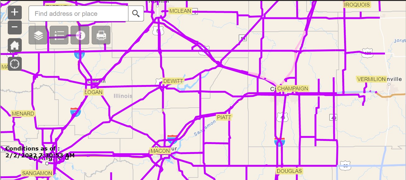
As the winter storm has died down, crews in Champaign County are finally able to make progress on clearing roads.
Every highway in Champaign County is at least slightly cleared of ice and snow, according to the Illinois Department of Transportation. This is a major change from yesterday, when all roads were fully covered. Many highways to the north of Champaign, including Interstate 57, have even switched to the “partly covered” category.
IDOT warns though that many roads are still far from clear. With low temperatures, road salt tends to be less effective in melting the ice. The department also requests that cars give plows room to work and reminds drivers that the safest place to be is behind the plow.
In the cities, the Urbana Public Works Department is working on plowing every street by noon. The department was able to start clearing residential streets overnight, after focusing on main streets throughout the storm.
“The streets are in better condition than yesterday. When people do try to get out, remember that the roads are still snow packed and there is still ice underneath certain areas. The roads may look clear, but I would remind drivers to be slow and cautious,” says Urbana Public Works Deputy Director Vince Gustafson.
Champaign County also aims to open rural roads shortly. The county continued to plow on Thursday night, unlike the previous night when high winds made plowing rural roads dangerous.
“Yesterday, we had a whole bunch of people stuck on the road, with snow piling up around vehicles. Hopefully we’re past that,” says Champaign County engineer Jeff Blue.
Champaign-Urbana Mass Transit District continues to reroute some buses – now only on the Red, Gold and Pink routes — to avoid problem patches. MTD maintains an updated list of route changes here.
POSTED FRIDAY AT 9:50 AM
Despite the sun coming out, roads remain very icy in Vermilion County, causing backups on I-74 according to the State Police. Additionally, the National Weather Service says well have subzero temperatures this weekend. So the snow melt will be very slow.
Piatt and Champaign counties: @ISPDistrict10 reports a "significant backup" on eastbound Interstate 74 between Mansfield and Mahomet as traffic slows for crashes on the shoulder.
— IDOT_Illinois (@IDOT_Illinois) February 4, 2022
M.Sgt Holley also asks that you "not slow unnecessarily for a good picture or video." pic.twitter.com/bAqAaYsFSB
Vermilion County: The right lane of eastbound Interstate 74 is blocked at milepost 218, about 2 miles from the Indiana state line, because of a crash. pic.twitter.com/IL349FzRqz
— IDOT_Illinois (@IDOT_Illinois) February 4, 2022
Bitter cold conditions are expected tonight, with temperatures dropping to below zero and wind chills in the -10 to -20 degree range. #ILwx pic.twitter.com/sTSN58jUU5
— NWS Lincoln IL (@NWSLincolnIL) February 4, 2022
POSTED FRIDAY AT 7:45 AM
Snow has finally stopped falling across most of Illinois Friday morning, but travel remains hazardous in many parts of the state.
Chambana Weather meteorologist Andrew Pritchard has been updating us throughout the week on this storm.
He spoke with Illinois Newsroom’s Brian Moline early Friday morning from the road, and believe it or not, he’s talking with some people in Iowa about Spring weather.
POSTED FRIDAY AT 6:50 AM
Another major traffic issue on I-57 south of Champaign-Urbana.
Douglas County: Multiple jack-knifed semis are blocking both lanes of northbound Interstate 57 at Arcola. Traffic is being detoured to US 45 (exit 203). pic.twitter.com/0Tud4cssHU
— IDOT_Illinois (@IDOT_Illinois) February 4, 2022
POSTED THURSDAY AT 5:45 PM
A second major traffic issue along I-74 in Champaign County.
Champaign County: Eastbound Interstate 74 is blocked at Mahomet because of multiple jack-knifed semis. State police are detouring traffic at Mansfield (exit 166). pic.twitter.com/tlprYptaFb
— IDOT_Illinois (@IDOT_Illinois) February 3, 2022
POSTED THURSDAY AT 5:00 PM
The city of Champaign says it is working around the clock to clear streets of nearly 13 inches of fresh snow. Crews will treat primary routes and get the streets down to near bare pavement first. Then begin working on secondary routes by tomorrow night. Champaign police have also implemented the Emergency Traffic Crash procedure. That means only traffic crashes involving an injury or vehicles that cannot be driven from the scene will be investigated by officers. If there is a crash and damages are estimated at less than 15-hundred dollars, the drivers involved can file reports with police once the Emergency Traffic Crash procedure is lifted.
As the snow winds down, the problems on the roadways continue to persist.
Champaign County: Both lanes of eastbound Interstate 74 are blocked at milepost 187, just past Urbana, because of a crash involving multiple semis.
— IDOT_Illinois (@IDOT_Illinois) February 3, 2022
Traffic is being detoured to University Avenue/US 150 (exit 185). pic.twitter.com/CKvBmXB2X9
Snow will end from northwest to southeast this evening. Gusty winds will continue into the evening, but start to taper off overnight. Bitter cold is expected tonight and Friday night as wind chills fall below zero. No additional precip is expected through this weekend. #ILwx pic.twitter.com/eOr0lOmNtz
— NWS Lincoln IL (@NWSLincolnIL) February 3, 2022
POSTED THURSDAY AT 3:30 PM
The winter storm is making driving very dangerous.
East-central Illinois has seen 61 crashes over the past two days – almost twice as many as the region saw all of last week.
Illinois State Police trooper and spokesperson Josh Korando says icy conditions contributed to many of this week’s accidents in ISP District 10.
“It seems like, ‘I’m driving just fine,’ and they start increasing their speed up to the speed limit. Then they need to stop and their car doesn’t stop – usually until it hits something like a dry spot in the road or something solid,” Korando says.
District 10 covers nine counties, including Champaign, Vermillion and Macon.
State police report that no one has died in any crashes in Illinois during the snow storm so far.
Three drivers have crashed into state police cars during the storm, leaving two state troopers with minor injuries.
Drivers are also finding themselves stuck in snow all across Illinois.
According to another Illinois State Police spokesperson, Sgt. Christopher Watson, 1,731 motorists have called for assistance statewide since the snow storm began early Wednesday morning.
That’s six times the number of motorists who called for help last week during this time.
Korando says the time it takes police to get to stranded drivers can vary.
“We have such a big area, it just varies. It just depends on where the call comes from and where our troopers are coming from,” Korando says.
State police include undamaged cars that have slid off the road in their motorist assist count.
Korando says police will continue to help stranded drivers for the remainder of the storm. Still, he says the fewer cars on the road, the easier it is for snow crews and first responders to do their jobs.
POSTED THURSDAY AT 11:20 AM
Major interstate closures continue in and around Champaign County. Meanwhile, the National Weather Service in Central Illinois says Champaign has ‘officially’ received 7 inches of snow so far.
🆕 Update 11:21 am: @ISPDistrict10 has closed southbound Interstate 57 at exit 220 again because of another semi crash. Traffic is being detoured to US 45.
— IDOT_Illinois (@IDOT_Illinois) February 3, 2022
https://twitter.com/IDOT_Illinois/status/1489286989706932228
Here is an observed snowfall map through this morning. ❄️
— NWS Lincoln IL (@NWSLincolnIL) February 3, 2022
The highest amounts fell within a swath between the IL River & I-72 where approximately 8-15" were reported. Snow amounts east of the IL River are not yet final as it is still snowing. #ilwx pic.twitter.com/3gp9cL2Cz3
Effingham County: Both lanes of northbound Interstate 57 are blocked at milepost 156, just south of Effingham, because of multiple semi crashes. Traffic is being detoured to Illinois 37 (exit 151). pic.twitter.com/KyUdhxxkWs
— IDOT_Illinois (@IDOT_Illinois) February 3, 2022
POSTED THURSDAY AT 9:10 AM
Major highway closure in Champaign County.
Champaign County: @ISPDistrict10 reports that all lanes of southbound Interstate 57 are blocked by a jack-knifed semi just past the Pesotum/US 45 (exit 220). Traffic is being detoured to US 45 there. pic.twitter.com/ZiEbHWWl4D
— IDOT_Illinois (@IDOT_Illinois) February 3, 2022
POSTED THURSDAY AT 8:25 AM
Police and road crews are urging people to avoid driving or be more cautious if they must drive today. Conditions remain treacherous.
Snow continues today, with the highest amounts generally south of Interstate 72 and ice in far southern counties. Blowing and drifting snow will be a problem all over the state.
— IDOT_Illinois (@IDOT_Illinois) February 3, 2022
Road conditions as of 7:45 am via https://t.co/3vgPqL82JK. pic.twitter.com/G3LjyKJuGx
Roads across central & southern Illinois remain completely snow + ice covered on Thursday morning. With snow + high winds continue through the day, this will not improve over the next 12 hours.
— Andrew Pritchard (@skydrama) February 3, 2022
Stay home if you can, go slow if you must. Many towing companies have suspended ops. pic.twitter.com/hJESmSf2ai
POSTED THURSDAY AT 8:15 AM
It’s been a busy couple of days for meteorologist Andrew Pritchard. He’s been closely tracking the winter storm that has dumped snow and ice across much of the country, including here in Illinois.
Illinois Newsroom’s Brian Moline spoke with Andrew about what people can expect if they have to head outside this morning.
Pritchard says we should expect another 2-4 inches of snow in Champaign County by 6pm today. He says that snow will continue to blow and drift, especially in rural areas.
One more day of winter storm conditions across Champaign County with 2" to 4" of new snow falling on Thursday. We'll quiet down quickly with a sunny & cold weekend ahead. #ilwx #uiuc #chambana pic.twitter.com/eiRYvPEl86
— Chambana Weather (@ChambanaWX) February 3, 2022
POSTED THURSDAY AT 7:40 AM
Snow has completely covered all highways in Champaign County. That includes interstates 57, 72 and 74, as well as U.S. Highway 36 through Rantoul and U.S. Route 45 through Savoy.
In the cities, roads are snow packed.
Urbana Public Works Deputy Director Vince Gustafson says the major arterial roads are passable. He still requests that those who can stay home, do so.
Both Champaign and Urbana have focused on plowing the main roads. Gustafson says that the Urbana Public Works Department started plowing some residential areas last night. However, as snow picks back up today, the department will return to its focus on primary streets.
“There will be some residential zones that have probably not even seen a plow,” Gustafson says.
However, the department will be available to smooth the way if any emergency vehicles need to get to those areas.
Champaign County did not plow the rural roads overnight, because wind speeds in the rural areas made it hard for snow crews to see. Although high wind speeds continue, the county crews have restarted their road clearing efforts this morning.
The Champaign-Urbana Mass Transit District has changed some of its bus routes to avoid snow-blocked areas like side streets. MTD has listed specific route changes on its website.
In addition, the Champaign County Area Rural Transit Service is not operating at all.
POSTED THURSDAY AT 6:00 AM
Crews in Danville working hard to keep streets open
Danville public works director Carl Carpenter says street crews were able to keep up with yesterday’s heavy snowfall. Carpenter says the city’s arterial roads were drivable much of the day, and the break in the snow gave them an even bigger chance to catch up. Carpenter says the city concentrated on residential areas during the overnight hours to avoid having to plow several inches of heavy snow that accumulated from both snowfall events. “We currently are in our 12 hour shifts which means we’re running half the crew from 7:00 a.m. to 7:00 p.m. and the other crew will come in at 7pm and work through the night,” said Carpenter. “From what I’m seeing the lull should last about 6 to 8 hours and that will give us enough time to get into our residentials.” If you’re in Danville and you think your neighborhood was skipped, call public works at 217.431.3452.
6 am — Latest road conditions from @IDOT_Illinois continue to show widespread snow covered roads. Give the plows extra room to work. #ILwx pic.twitter.com/90trP4YdFo
— NWS Lincoln IL (@NWSLincolnIL) February 3, 2022
Here are the latest road conditions. As you can see, it is a mess over nearly the entire state. Please stay home if you are able to give our crews more room to work.
— IDOT_Illinois (@IDOT_Illinois) February 3, 2022
Check https://t.co/nTSJWJkaXv for more. Traffic cam image from I-55/70 near Collinsville. pic.twitter.com/pr6AGsMFjv
POSTED THURSDAY AT 5:30 AM
The National Weather Service in Lincoln says steady snow continues to roll across Illinois.
5:33 am — Snow will be fairly steady across most areas south of I-72 this morning, but the northern edge of it shouldn't get much further north than it is now. #ILwx pic.twitter.com/vWJNlPpLnN
— NWS Lincoln IL (@NWSLincolnIL) February 3, 2022
5am: light but steady snow in Champaign #Illinois @NWSLincolnIL @skydrama @ChambanaWX #WinterStorm ❄️ ⛄️ pic.twitter.com/GjckhjSUfA
— Illinois Public Media News (@IPMnewsroom) February 3, 2022
3:40 am — Wind gusts 30+ mph will continue today, especially I-55 east, resulting in areas of blowing and drifting snow. #ILwx pic.twitter.com/4JW074giFm
— NWS Lincoln IL (@NWSLincolnIL) February 3, 2022
POSTED WEDNESDAY AT 9:30 PM
https://illinoisnewsroom.org/more-snow-expected-to-move-in-after-midnight-impacting-areas-south-of-i-72-and-danville/
POSTED WEDNESDAY AT 4:00 PM
The National Weather Service in Central Illinois says blowing and drifting snow with 1-3 foot drifts are forming with north wind gusts 25-40 mph. Visibilities are reduced as well.
Bands of heavier snow will lift NE across portions of central and eastern IL from I-55 east this afternoon. Blowing and drifting snow with 1-3 foot drifts with north wind gusts 25-40 mph. Vsbys reduced to 1/4 to 1/2 mile or less at times. Stay home if possible, many roads closed. pic.twitter.com/4FJgHKdHr1
— NWS Lincoln IL (@NWSLincolnIL) February 2, 2022
Our first round of heavy, drifting snow is starting to come to an end. But round two is on the way! Illinois Newsroom’s Reginald Hardwick talked with Meteorologist Andrew Pritchard about what’s ahead for us tonight, tomorrow and this weekend.
POSTED WEDNESDAY AT 3:45 PM
Champaign County will stop plowing snow off rural roads at sundown tonight.
Jeff Blue is a Champaign County engineer. He says high forecasted winds will make plowing at night both unhelpful and dangerous.
“The forecasted gusts of winds are 35 miles per hour tonight. [With] white out conditions during dark hours, we just can’t see where we’re going. We become more of a hazard than we are helping out there,” Blue says.
The county plans to reassess conditions in the morning. Blue says he does not expect the high winds to stop — or for road conditions to improve – until Friday.
In the meantime, his department will station plows throughout the county in case an ambulance or fire truck gets stuck in the snow.
None of the other snow crews in the area have announced similar pauses. Spokespeople in the Champaign and Urbana public works departments say that they plan to continue to work through the night.
According to Urbana Deputy Public Works Director Vince Gustafson, winds don’t pose the same risk to urban snow crews as they do in rural areas.
POSTED WEDNESDAY AT 1:35 PM
Heavy snow impacting Danville
DANVILLE – More closures and cancellations in Vermilion County as heavy snow continues to fall there. Several schools have already moved to close Thursday as snow accumulation continues to build throughout Danville and Vermilion County. According to local authorities, the road conditions are hazardous and several traffic accidents have been reported on both city and rural roads. The city is asking residents to keep their cars off of public streets to allow snow removal crews to move snow quickly. Danville has also halted all public transportation services until at least Friday.
IDOT cameras also show numerous traffic issues in McLean county.
Numerous crashes and slide-offs continue to plague Interstate 55 from Grundy to McLean counties, mostly in the southbound lanes. Here's a look at milepost 184, about halfway between Chenoa and Lexington: pic.twitter.com/dqE4zpCsbU
— IDOT_Illinois (@IDOT_Illinois) February 2, 2022
POSTED WEDNESDAY AT 12:25 PM
The National Weather Service is warning that increasing winds and heavy snow are causing treacherous road conditions as well as terrible visibility.
Treacherous travel conditions will continue this afternoon. Northerly wind gusts over 30 mph are expected, which will create blowing and drifting snow. Visibility is less than one mile across the area, and numerous accidents are being reported. Stay home if at all possible. #ILwx pic.twitter.com/qMaiwUY8u9
— NWS Lincoln IL (@NWSLincolnIL) February 2, 2022
Bands of heavier snow are lifting northeast across central IL from I-55 east at midday. Blowing pic.twitter.com/L3PDwSUIz9
— NWS Lincoln IL (@NWSLincolnIL) February 2, 2022
POSTED WEDNESDAY AT 12:00 PM
Heavy snow and gusty winds are outpacing snow removal crews across Champaign-Urbana #ilwx and road conditions continue to deteriorate. pic.twitter.com/zJJmo0DURL
— Andrew Pritchard (@skydrama) February 2, 2022
Sheets of heavy snow falling in downtown Urbana around 10 AM pic.twitter.com/bKSyvTxyRt
— Chambana Weather (@ChambanaWX) February 2, 2022
POSTED WEDNESDAY AT 10:30 AM
Snowfall in Champaign County has gotten heavier over the last hour and a half, making plowing more difficult for local snow crews.
“Right now, the snow exceeds our capacity. We finish a route and you can hardly tell we were there,” says Urbana Deputy Public Works Director Vince Gustafson.
Gustafson’s crews started plowing around 11 p.m on Tuesday. The crews are slightly short-staffed at about 13 full time people per shift. Some employees are home because of COVID-19, and there are a few vacancies in the department.
Rantoul snow crews started to plow at around 3:30 a.m. Nine people make up the full snow crew.
“We’re in some pretty heavy snow. It’s all we can do to keep up,” says Rantoul street foreman Mike Esslinger.
Esslinger says the snow has largely closed the roads in Rantoul.
Snow has blanketed every highway in the county, according to the Illinois Department of Transportation. This now includes Interstates 57 and 74. The stretches of those highways between Champaign, Rantoul and Mahomet were the last to switch from IDOT’s “mostly covered” category to fully covered.
To see updated maps of Champaign County highways, visit gettingaroundillinois.com.
Roads conditions in Urbana #Illinois are deteriorating with the heavier snow and winds. Officials are advising you to stay home if you can. ❄️ ☃️ @NWSLincolnIL @ChambanaWX @skydrama pic.twitter.com/OAtqlLGFXo
— Illinois Public Media News (@IPMnewsroom) February 2, 2022
Snow is really coming down near @UofIllinois campus. Plenty of wind as well. @NWSLincolnIL @skydrama @ChambanaWX #WinterStorm pic.twitter.com/j6nuXFMIsZ
— Illinois Public Media News (@IPMnewsroom) February 2, 2022
POSTED WEDNESDAY AT 9:20 AM
Snowfall rates and the number of vehicle crashes continue to increase.
Numerous crashes on both sides of Interstate 55 in McLean and Livingston counties have led to another closure, this time northbound at about milepost 188, near Chenoa and the Livingston County line.
— IDOT_Illinois (@IDOT_Illinois) February 2, 2022
Road conditions as of 9:10a via https://t.co/3vgPqL82JK. pic.twitter.com/CLvsnaFpFr
Bands of heavy snow are crossing central Illinois, reducing visibility to a quarter mile or less, and causing rapid snow accumulations. Many accidents have been reported on area interstates. Stay home if at all possible. pic.twitter.com/XlSfuUxbPT
— NWS Lincoln IL (@NWSLincolnIL) February 2, 2022
POSTED WEDNESDAY AT 8:25 AM
Central Illinoisans are waking up to a Winter Storm Warning. Steady snowfall is underway and forecasters expect a foot of snow before the system leaves us tomorrow evening. Illinois Newsroom’s Reginald Hardwick talked with meteorologist Andrew Pritchard about what we can expect through the day, as well as tonight and tomorrow.
A Winter Storm Warning continues until Thursday evening. Expect periods of heavy snow through the day today, with a lull in the evening and early overnight. Light snow will resume late tonight into Thursday morning before tapering off for good late in the day on Thursday. pic.twitter.com/AyUdU0qtJK
— Chambana Weather (@ChambanaWX) February 2, 2022
Heavy snow and blustery winds in Urbana #ilwx at 8 AM pic.twitter.com/ySTQhLODpX
— Andrew Pritchard (@skydrama) February 2, 2022
Starting to see multiple accidents on I-74 in Vermilion County. Roadways are deteriorating quickly. If you must be out on the roads, be very careful, have an emergency kit with you and make sure your cell phone is fully charged so you can call for help if you get in trouble.
— Vermilion County EMA (@VermilionEma) February 2, 2022
Road conditions at Prospect and I-74 in Champaign.
— Jacob Dickey, WCIA 3 News (@jacobdickeywx) February 2, 2022
Photo: Jalen Duncan pic.twitter.com/zHmNCNc8kZ
POSTED WEDNESDAY AT 8:05 AM
The National Weather Service says 1 to 2 inches of snow has already fallen in the Champaign Urbana area this morning. Peoria has already received 8 to 12 inches of snow. And the Quincy area on Illinois’ western border has 12 to 18 inches of fresh snow this morning. Within the hour, the Illinois State police closed southbound I-55 near Lexington in the northern part of McLean County because of multiple crashes. The Illinois Department of Transportation is urging you to stay home and off of the roads if you can.
We have a live Facebook video right now looking north from our Illinois Public Media studios towards the intersection of Goodwin and University Avenue in Urbana.
7:25 am — Early look at snowfall amounts across the state show the heaviest band extending from Quincy to Chicago, focused on west central Illinois. Heaviest reports include 11" at Lewistown and 10" at Vermont, both in Fulton Co. #ILwx pic.twitter.com/1U6qZvCMHw
— NWS Lincoln IL (@NWSLincolnIL) February 2, 2022
McLean County: The @ILStatePolice have CLOSED southbound Interstate 55 at milepost 178, near Lexington in the northern part of the county, because of multiple crashes. pic.twitter.com/SOsQq0vyG4
— IDOT_Illinois (@IDOT_Illinois) February 2, 2022
That's a whole lot of magenta ahead of the morning commute. Again, staying home is the safest option if it is available to you.
— IDOT_Illinois (@IDOT_Illinois) February 2, 2022
Our crews have been out working hard since late last night, but the snow is too heavy in some areas to be able to keep up. pic.twitter.com/QdEmneupU9
POSTED WEDNESDAY AT 7:30 AM
Light snow and ice has covered the roads all over Champaign County.
According to Champaign County engineer Jeff Blue, the roads are safe to drive for now, as long as drivers use caution.
“Things are slippery, but they’re not packed up and hazardous yet,” Blue says.
The first Champaign County crews started plowing rural roads on Wednesday morning, after about an inch of snow had accumulated.
Blue expects conditions to worse throughout the day.
The Illinois Department of Transportation maintains and updates a winter conditions map on gettingaroundillinois.com.
According to the map, highways like Interstate 72 are covered in snow or ice throughout Champaign County. Conditions are slightly better on the stretches of I-57 and I-74 between Champaign and Rantoul and Mahomet, respectively.
While the roads were relatively clear in the south of Champaign County at 6 a.m, those highways are now covered in snow as well.
POSTED WEDNESDAY AT 6:00 AM
Steady snowfall across the Champaign-Urbana area.
5:48 am — Freezing rain and sleet mixture continues to edge south toward I-70. #ILwx pic.twitter.com/9qKp88nVzP
— NWS Lincoln IL (@NWSLincolnIL) February 2, 2022
5:20 am — Latest road condition reports from @IDOT_Illinois show widespread snow covered roads. #ILwx pic.twitter.com/dHsgNsG3BB
— NWS Lincoln IL (@NWSLincolnIL) February 2, 2022
Steady snowfall ❄️ in Champaign #Illinois @NWSLincolnIL @ChambanaWX @skydrama pic.twitter.com/LUcy2HBIHB
— Illinois Public Media News (@IPMnewsroom) February 2, 2022
4:20 am — Latest storm total snow and ice forecasts. Area east of IL River and north of I-70 will see the heaviest snow. #ILwx pic.twitter.com/6Pj4HxiCNO
— NWS Lincoln IL (@NWSLincolnIL) February 2, 2022
4:35 am — Breakdown on precipitation timing through Thursday. A pause in the snow is expected later this afternoon and evening. #ILwx pic.twitter.com/tEb5d8g2u2
— NWS Lincoln IL (@NWSLincolnIL) February 2, 2022
POSTED WEDNESDAY AT 12:35 AM
The National Weather Service reports the changeover to icy precipitation is approaching the Champaign and Decatur areas. This will make roadways very slick.
12:23 am — Changeover of mixed precipitation approaching Decatur and Champaign. #ILwx pic.twitter.com/OJO5vCi5pN
— NWS Lincoln IL (@NWSLincolnIL) February 2, 2022
POSTED WEDNESDAY AT 12:25 AM
With a massive winter storm expected to blanket the entire state in ice and snow, Gov. JB Pritzker on Tuesday issued a disaster declaration and activated members of the Illinois National Guard. He also announced that his regularly scheduled State of the State and budget address would go on as planned at noon Wednesday, only at a new venue – the Old State Capitol in Springfield. Read more below from Capitol News Illinois.
https://illinoisnewsroom.org/pritzker-declares-disaster-for-snow-event-will-forge-ahead-with-in-person-budget-address/
POSTED TUESDAY AT 11:40 PM
Many education instutions will hold “remonte learning days” on Wednesday because of the forecasted winter storm, including:
- University of Illinois, Urbana-Champaign
- Champaign Unit 4 Schools
- Urbana School District 116
- Decatur Public Schools
- Monticello CUSD #25
- Eastern Illinois University
Many city and county office buildings will be closed on Wednesday and Thursday, including:
- Champaign City Building
- Champaign County Courthouse and Sheriff’s Administrative office
- Urbana City Building, Public Works Building, Landscape Recycling Center, and Urbana Free Library
- Champaign-Urbana Public Health District, including locations in Champaign, Rantoul and Watseka
- Vermilion County offices
- City of Danville buildings
- Macon County Health Department
This is just a PARTIAL list of the closings. Click here for the full list of winter storm closings and cancelations.
All performances scheduled for We, Th, and Fr will take place. This could change depending on weather conditions. A decision regarding Wednesday night will be announced after 3pm Wednesday. A decision regarding Th and Fr nights will be announced as more information is available. pic.twitter.com/atmfkztiBI
— Krannert Center (@KrannertCenter) February 1, 2022
POSTED TUESDAY AT 11:25 PM
The National Weather Service reports that the winter storm is changing over from rain to a freezing rain/sleet mixture as it advances southeast. Heavy snow has already begun in the Peoria area.
11:25 pm — Roads quickly becoming snow covered around Peoria, with 1 to 2 inches of snow already reported. This @IDOT_Illinois webcam is at I-74 at the Fondulac Bridge. #ILwx pic.twitter.com/JPaNK5SSmd
— NWS Lincoln IL (@NWSLincolnIL) February 2, 2022
10:45 pm — Changeover to mixed precip was roughly centered along I-55 and advancing southeast. #ILwx pic.twitter.com/Cm3rhKyxcX
— NWS Lincoln IL (@NWSLincolnIL) February 2, 2022
POSTED TUESDAY AT 5:15 PM
Champaign, Urbana crews plan to start plowing tonight
CHAMPAIGN — Snow crews across Champaign County plan to work twelve-hour shifts – starting tonight — to clear the roads.
In the city of Champaign, 25 people will staff each shift. The first shift is scheduled to start on Tuesday night around 11 p.m.
Champaign Public Works spokesperson Kris Koester says this is a once-in-a-decade kind of storm for his department.
“We’ve had prolonged snow over several days, but within a day and a half – that’s going to be a lot of snow coming in a short amount of time,” Koester says.
Koester requests that people stay home and park off the road as much as possible on Wednesday and Thursday.
Those who have to drive in the city of Champaign can expect primary streets like Bradley Avenue and State Street to be clearer than side streets. (Find the city’s map of primary streets here.)
“We estimate that 90 percent of people live within two to three blocks of a primary street, so if you can get to a primary street, you’ll see that things are in a little bit better condition,” Koester says.
But, Koester says not to expect any streets to be completely clear until the snow stops.
For those who do have to drive, Koester recommends driving slowly — with a full tank of gas and a working cell phone.
Urbana and Champaign County also plan to send out crews on Tuesday night to plow the snow. 10 people staff each Champaign County shift, while 12 people staff Urbana’s.
All three local governments plan to keep alternating crews every twelve hours until the snow stops.
POSTED TUESDAY AT 5:00 PM
Risky travel wrought by snow, wind cancels legislative work
SPRINGFIELD, Ill. (AP) — The Illinois General Assembly has canceled its three scheduled days of session this week as the central part of the state prepares for a major winter storm expected to bring heavy snow, ice and high wind gusts to the region. Gov. J.B. Pritzker declared a state of emergency ahead of the storm which forced lawmakers to cancel meetings on Tuesday through Thursday. Wednesday was set aside for a joint legislative session to hear Pritzker deliver the annual State of the State address and propose a new state spending plan. Pritzker will proceed with the speech, but at the historic Old State Capitol in downtown Springfield. – Associated Press
This afternoon, the National Weather Service expanded the Winter Storm Warning to include more counties. Meteorologists say drivers hould expect very difficult travel across the Midwest through Thursday.
The Winter Storm Warning has been expanded to include all counties covered by our office (and much of the surrounding area). Expect very difficult travel across the Midwest through Thursday! #ILwx pic.twitter.com/5BOjnfBXZc
— NWS Lincoln IL (@NWSLincolnIL) February 1, 2022
Northerly wind gusts are expected to increase over 30 mph by Wednesday afternoon, and remain elevated through the day Thursday. Power outages may occur, with the greatest potential being in areas where ice accumulates. #ILwx pic.twitter.com/ZAWdKu8JHB
— NWS Lincoln IL (@NWSLincolnIL) February 1, 2022
POSTED TUESDAY AT 2:50 PM
According to the National Weather Service in Central Illinois, the heaviest snowfall will happen Wednesday 3:00-6:00 a.m.
Here's a look at the expected timing of precipitation changes through midday on Wednesday. Darker shades indicate heavier precipitation. Heavy snow is likely overnight tonight into Wednesday morning. Additional snow is expected beyond 12 PM Wednesday. #ILwx pic.twitter.com/jkjRBK5DEv
— NWS Lincoln IL (@NWSLincolnIL) February 1, 2022
The band of heaviest snow will slowly shift southeast across the area this evening through Thursday. Some of the heaviest snow will fall late tonight into Wednesday morning over central Illinois with a secondary peak Thursday night over east central and southeast Illinois. #ilwx pic.twitter.com/SJ1sp7qkD4
— NWS Lincoln IL (@NWSLincolnIL) February 1, 2022
POSTED TUESDAY 2:44 PM
The University of Illinois says it will NOT close for the winter weather but there will only be ‘essential operations’ essential operations on Wednesday, Thursday and Friday. Classes will move to online.
POSTED TUESDAY, 2:00 PM
Governor JB Pritzker is expected to provide updates on preparations for the winter storm from the IEMA State Emergency Operations Center at 2:00 p.m. Click here to stream his announcements.
The Illinois Department of Transportation is advising people to stay home while the winter storm crosses Illinois. For drivers who must travel, they are advising they build an emergency kit in case they become stranded on snow covered highways.
A potentially record-breaking winter storm is headed our way, with some areas in central Illinois possibly seeing as much as 18-20 inches of snow and southern Illinois getting ice and heavy rain.
— IDOT_Illinois (@IDOT_Illinois) February 1, 2022
Two words of advice: Stay home. https://t.co/Fh4JxIf3Jn
.@NWSLincolnIL says that travel will be nearly impossible at times and given the amount of snow in the forecast, it's possible that you could become stranded. If you *absolutely* must travel, be sure to have a full tank of gas and an emergency kit in case you do become stranded. pic.twitter.com/NqzlmpVaRk
— IDOT_Illinois (@IDOT_Illinois) February 1, 2022
POSTED TUESDAY, 1:30 PM
City and school closures are starting to pour into Illinois Public Media News. Danville District 118 and Monticello CUSD #25 will be closed Wednesday and Thursday. Also closed on those days: the Champaign City Building, Township office, and Public Library as well as the Champaign County Courthouse and Sheriff’s Administrative office. Click here to check for closings around East Central Illinois.
The National Weather Service in Lincoln is warning people not to be fooled by this afternoon’s warm weather. Much colder air and heavy snowfall are still on the way. They’re also offering advice on properly measuring and reporting the snow that falls.
A powerful winter storm is expected to bring significant snow to the area. We'd love any snow reports as you're able to take them! Here are some best practices for measuring snow. Snow is expected to begin late tonight, so if you have a board you should put it out today #ILwx pic.twitter.com/uvsgG0KM3f
— NWS Lincoln IL (@NWSLincolnIL) February 1, 2022
Current temps are some of the warmest across central IL since December, but don’t be fooled! A strong cold front will plunge into the area tonight, setting the stage for our major winter storm. Much colder temps are expected by this time tomorrow. #ILwx pic.twitter.com/QiaXBE585w
— NWS Lincoln IL (@NWSLincolnIL) February 1, 2022
POSTED TUESDAY, 8:00 AM
The Village of Rantoul in Champaign County will enact emergency snow routes starting Tuesday at 11:00 p.m. Vehicles along snow routes will be towed. Public Works and Recreation staff will begin de-icing and plowing operations late Tuesday, early Wednesday morning. The village plans to staff the phone number 217.892.6800 from Tuesday at midnight to Friday at 5:00 p.m. for anyone in the public needing assistance or resources during the storm event.
Danville Public Works says plows will begin clearing streets with “two passes on each street” while the snowfalls. They’ll clear snow curb to curb after it comes to an end. They’re asking people to clear cars off of streets before the storm.
POSTED TUESDAY, 7:45 AM
The National Weather Service updated its forecast earlier this morning. The heaviest snowfall rates and most difficult travel will start Wednesday morning.
4:30 am — A breakdown of the snow amounts over 12 hour periods. The heaviest snow will fall Wednesday morning. #ILwx pic.twitter.com/y41eI2T2Dh
— NWS Lincoln IL (@NWSLincolnIL) February 1, 2022
Good Tuesday morning! A Winter Storm Warning goes into effect at 9 PM tonight and lasts until 6 PM Thursday. We're still a ways off from the worst impacts of the upcoming winter storm. Rain will begin this afternoon, and transition to a wintry mix overnight as temperatures fall. pic.twitter.com/fbFqq5BLbB
— Chambana Weather (@ChambanaWX) February 1, 2022
3:52 am — Updated summary on when the main winter storm impacts will be in central and southeast Illinois. #ILwx pic.twitter.com/ClWgUr3QP2
— NWS Lincoln IL (@NWSLincolnIL) February 1, 2022
3:15 am — Winter Storm Warning has been expanded to cover most of central Illinois, with the Winter Storm Watch continuing in portions of southeast Illinois. #ILwx pic.twitter.com/MffbnFeyRM
— NWS Lincoln IL (@NWSLincolnIL) February 1, 2022
POSTED MONDAY, 11:20 PM
POSTED MONDAY, 8:00 PM
URBANA – Wondering where all the snow this winter went? It may arrive during the first week of February 2022.
The National Weather Service in Lincoln placed much of Central Illinois under a Winter Storm Warning from Tuesday at 9:00 p.m.-Thursday 6:00 p.m. Meteorologists say up to a foot of snow is possible. The warning area includes Springfield, Decatur, Bloomington, Champaign-Urbana and Danville.
“A major winter storm will bring significant snow accumulation & a wintry mix Tue night into Thu.,” says the NWS in a tweet issued Monday at 4:30 p.m CT. The weather service advised people to brace for the following:
- dangerous to impossible travel
- power outages
- blowing and drifting snow Wednesday night into Thursday
Chambana weather meteorologist Andrew Pritchard is also watching the forecasts carefully. He says the winter storm will begin with rain.
“Preciptation will begin as rain on Tuesday afternoon transitioning into a wintry mix as temperatures fall below freezing Tuesday night,” says Pritchard. “Snow will begin to accumulate on Wednesday morning and then continue into the day on Thursday. Significant snow accumulation of around one foot is possible by Thursday evening with locally higher amounts possible.”
4:30 PM Update -⚠️ A major winter storm will bring significant snow accumulation & a wintry mix Tue night into Thu. Key highlights:
— NWS Lincoln IL (@NWSLincolnIL) January 31, 2022
-Dangerous to impossible travel expected
-Power outages possible
-Blowing & drifting snow Wed night into Thu
Plan now for impacts! #ilwx pic.twitter.com/y1Ggrdy473
With hazardous travel conditions expected Wednesday and Thursday, if you must travel, make sure your car is equipped with the necessary gear to survive in the event you become stranded. #ILwx pic.twitter.com/t79AKZw20m
— NWS Lincoln IL (@NWSLincolnIL) January 31, 2022
POSTED MONDAY, 10:00 AM
The National Weather Service in Lincoln issued a Winter Storm Watch for central and southeast Illinois. It begins Tuesday evening north of I-70, and lasts through Thursday evening. It indicates the risk of a hazardous winter weather event has increased (at least a 50% chance of it occurring), but its occurrence, location, and/or timing is still uncertain.
“Snow accumulations over 8 inches are likely in a large portion of central Illinois, Tuesday night through Thursday night. However, the potential is there for double-digit amounts,” said the NWS in a tweet issued Monday at 3:45 a.m. CT.
As of Monday, meteorologists expected a mix of freezing rain and sleet changing over to all snow on Wednesday. The National Weather Service in Lincoln forecasted areas south of I-70 will most likely see the wintry mix. And regardless of where you must travel on Wednesday and Thursday, it’s expected to be difficult.
As for the snow, Illinois Public Media meteorologist Andrew Pritchard said more accurate snow totals will become available on Monday. However several inches of snow are possible.
“It is possible one or more periods of heavy snowfall may occur on Wednesday and Thursday. In Champaign-Urbana, ensemble forecasts give a greater than 99% chance of more than 3″ of snow accumulation, with a 95% chance of more than 6″ of snow by Friday morning,” said Pritchard.
Why is there so much uncertainty about snow/ice amounts near the precip transition zone? Precip type depends on temps at the surface and above ground! Subtle differences in temperature can have a big impact, and it's difficult to pinpoint these differences days in advance. #ILwx pic.twitter.com/CLaJmQdUhW
— NWS Lincoln IL (@NWSLincolnIL) January 31, 2022
A MAJOR WINTER STORM appears increasingly likely across central Illinois with high impacts on Wednesday and Thursday.
— Chambana Weather (@ChambanaWX) January 31, 2022
As of Monday morning, current forecast guidance suggests rain will begin falling across Champaign County/east-central Illinois on Tuesday afternoon. pic.twitter.com/YswXM6Sckz
3:52 am — A Winter Storm Watch has been issued for central and southeast Illinois. It begins Tuesday evening north of I-70, and Wednesday afternoon to the south. #ILwx pic.twitter.com/hZhfHuaFuD
— NWS Lincoln IL (@NWSLincolnIL) January 31, 2022
3:45 am — Snow accumulations over 8 inches are likely in a large portion of central Illinois, Tuesday night through Thursday night. However, the potential is there for double-digit amounts. #ILwx pic.twitter.com/8z6fnRJ6dT
— NWS Lincoln IL (@NWSLincolnIL) January 31, 2022
A long-duration precipitation event, including the potential for significant snowfall is possible this week, Tuesday – Thursday, Feb 2-4. We are still 72 hours out from the potential highest impacts which leaves a lot of time for forecast adjustments. pic.twitter.com/roNAgsSfDM
— Chambana Weather (@ChambanaWX) January 30, 2022
A mix of freezing rain & sleet is possible as the rain changes to all snow Wed AM. Areas south of I-70 appear to be the most likely area. There is still uncertainty in the location Main point: If you have travel plans mid week, considerable travel difficulty is expected. #ILwx pic.twitter.com/vJJxrarjKn
— NWS Lincoln IL (@NWSLincolnIL) January 31, 2022