

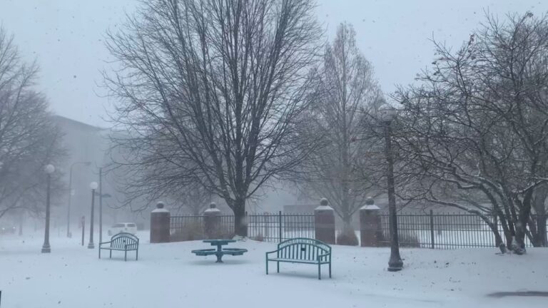
Illinois Public Media is tracking a winter storm system. Forecasters expect it to bring blowing snow and dangerously cold temperatures to Central Illinois on December 22 and 23. This story will be updated with posts from Chambana Weather meteorologist Andrew Pritchard and the National Weather Service. Closings and cancellations are being updated here.
Updated Friday at 8:30 a.m.
The snowfall may have moved on, but strong wind gusts are going to blow what’s on the ground all over the place, especially in rural areas on north-south roads. Conditions as of 8:25 am via https://t.co/3vgPqL8Azi. pic.twitter.com/8saI8tqIPm
— IDOT_Illinois (@IDOT_Illinois) December 23, 2022
… (the current wind chill is -39, this is not a “forecast”, this is just what it is out there and will continue to be through Saturday AM). Blowing snow will continue to reduce visibility and cover roadways, especially in rural areas.
— Chambana Weather (@ChambanaWX) December 23, 2022
The main point: I am sure you’re all great drivers. I know the snow accumulation does not look “impressive” out your window. Conditions will deteriorate rapidly at times in rural areas, and becoming stranded in this air mass may quickly become a life-threatening matter.
— Chambana Weather (@ChambanaWX) December 23, 2022
Wind chill temperatures as low as 38 below zero as of 6 am this morning, causing dangerously cold conditions. #ilwx pic.twitter.com/MNIAfPWs3l
— NWS Lincoln IL (@NWSLincolnIL) December 23, 2022
Updated Friday at 5:00 a.m.
3 am wind chills… 🥶 #ilwx pic.twitter.com/uQKlh0j6Ze
— NWS Lincoln IL (@NWSLincolnIL) December 23, 2022
Dangerously cold conditions are expected through Christmas morning in central IL, with wind chills as low as 40 below zero this morning. #ilwx pic.twitter.com/6sG79S74kF
— NWS Lincoln IL (@NWSLincolnIL) December 23, 2022
Updated Thursday at 5:30 p.m.
Areas of light snow along with patchy blowing snow resulting in sporadic whiteout conditions continue across central Illinois. Hazardous travel conditions, which will occur mainly in open/rural areas where blowing and drifting is maximized, will continue through Friday night. pic.twitter.com/67QwspGkHz
— NWS Lincoln IL (@NWSLincolnIL) December 22, 2022
Time to stay home, Champaign County. Emergencies and weather sickos only! ❄️🥶 pic.twitter.com/XfsAY9GIgm
— Chambana Weather (@ChambanaWX) December 22, 2022
Updated Thursday at 10:30 a.m.
We have received several closings and cancellations around the area related to the winter storm. You can find those listed here.
The buzz-word this morning is Snow Squall. What is it? What does it look like? #ILwx pic.twitter.com/P2V0IlL5zi
— NWS Lincoln IL (@NWSLincolnIL) December 22, 2022
[9:55 AM] – This’ll spell trouble. A snow squall is moving across Interstate 74 in between Davenport, IA and Peoria, IL. Near white-out conditions are expected along this stretch. pic.twitter.com/KZTjuJH5vO
— NWS Lincoln IL (@NWSLincolnIL) December 22, 2022
Updated Thursday at 7:30 a.m.
The National Weather Service has issued a Winter Storm Warning for most of central Illinois starting at noon Thursday. Chambana Weather meteorologist Andrew Pritchard has been tracking this storm all week. Illinois Newsroom’s Brian Moline spoke with Pritchard about the impending weather.
Listen to this interview here.
… winds gusting 45 to 50 mph will create white-out conditions and treacherous travel through Saturday morning. Wind chills as low as 35 BELOW ZERO are expected – this will make becoming stranded in your vehicle a life-threatening matter.
— Chambana Weather (@ChambanaWX) December 22, 2022
Updated Thursday at 6:00 a.m.
Wind chills to 15 degrees below zero expected by 6 pm this evening in central Illinois. Wind chills as cold as 30 to 35 degrees below zero expected by Friday morning. #ilwx pic.twitter.com/Rt3Sa7XTQD
— NWS Lincoln IL (@NWSLincolnIL) December 22, 2022
Accumulating snow will begin this morning west of I-57 in central IL, and this afternoon east of I-57, with 1 to 4 inches expected by this evening. Strong winds, blowing and drifting snow, and dangerous travel conditions expected. pic.twitter.com/HqXSzur1iv
— NWS Lincoln IL (@NWSLincolnIL) December 22, 2022
Updated Wednesday at 1:15 p.m.
We’re beginning to receive some closings and cancellations around the area related to the winter storm. You can find those listed here.
The National Weather Service in Lincoln has issued a Winter Storm Warning for the WILL Severe Weather Coverage area from noon Thursday until 6 a.m. Saturday.
* WHAT…Snow expected. Total snow accumulations of 2 to 4 inches. Winds gusting as high as 50 mph resulting in blowing and drifting snow. Visibility a quarter mile or less at times. Wind chill values as low as 30 below zero.
* WHERE…Portions of central, east central and southeast Illinois.
* WHEN…From noon Thursday to 6 AM CST Saturday.
* IMPACTS…Plan on slippery road conditions. Widespread blowing snow could significantly reduce visibility. The hazardous conditions could impact the morning or evening commute. Gusty winds could bring down tree branches and isolated power outages are possible. The cold wind chills as low as 35 below zero could cause frostbite on exposed skin in as little as 30 minutes.
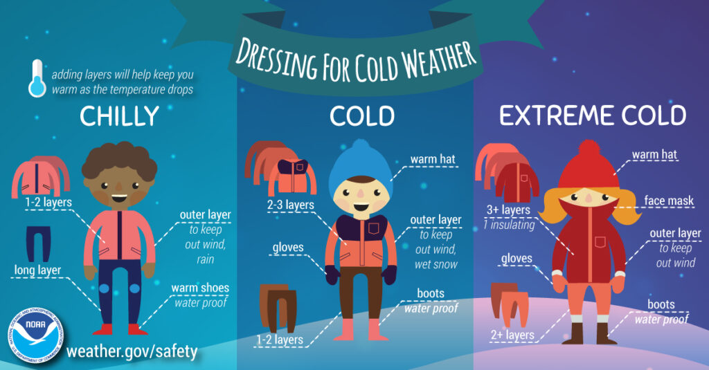
*PRECAUTIONARY/PREPAREDNESS ACTIONS… If you must travel, keep an extra flashlight, food, and water in your vehicle in case of an emergency. Avoid outside activities if possible. When outside, make sure you wear appropriate clothing, including multiple layers, hat, and gloves. The latest road conditions for Illinois can be obtained on the Internet at www.gettingaroundillinois.com
Updated Wednesday at 8:00 a.m.
Update on dangerous winter conditions in Champaign County/east-central Illinois Thursday – Saturday: pic.twitter.com/5rSDfcTQKl
— Andrew Pritchard (@skydrama) December 21, 2022
.. combined with winds gusting over 35-50 MPH and rapidly falling temperatures. I have trimmed my snow accumulation forecast back a bit to 1″ to 3″ for Champaign County and surrounding portions of east-central Illinois.
— Chambana Weather (@ChambanaWX) December 21, 2022
This is a minor snowfall historically speaking, but will become dangerous as strong winds creating blowing & drifting snow, reduced visibility, and potential blizzard conditions Thursday PM into the day on Friday. #ilwx #uiuc #chambana
— Chambana Weather (@ChambanaWX) December 21, 2022
A sharp drop in temperatures Thu PM will add another degree of danger to things as wind chills drop as low as -25 to -35 by Friday morning. Be sure to dress or pack appropriate cold weather clothing if you will be out traveling through the weekend. #ilwx https://t.co/yJ4lxt6FcX
— NWS Lincoln IL (@NWSLincolnIL) December 21, 2022
In addition to however much snow we’ll get, it’s going to get windy and 🥶 COLD. 🥶 Make sure you have a blanket in your emergency kit in case you get stranded. pic.twitter.com/CKLpwT5Q8q
— IDOT_Illinois (@IDOT_Illinois) December 21, 2022
Updated Tuesday at 7:00 a.m.
Tuesday AM update on late-week winter storm potential in Champaign County / east-central Illinois: pic.twitter.com/HOt5YuOQtP
— Chambana Weather (@ChambanaWX) December 20, 2022
…but snow becomes heavy Thursday night into Friday morning as winds become blustery. Blowing snow, blizzard conditions, and dangerously cold temperatures take us through the day Friday into Saturday. We’ll begin to thaw out and clear up Sunday into next week. #ilwx #uiuc
— Chambana Weather (@ChambanaWX) December 20, 2022
Dangerously cold wind chills of -25 to -30 degrees are expected Thursday night into Friday morning. If you must be outdoors during this time, be sure to dress in layers and cover any exposed skin. Bitterly cold wind chills are also expected Saturday and Sunday mornings. #ilwx pic.twitter.com/gQDWdSGAkF
— NWS Lincoln IL (@NWSLincolnIL) December 20, 2022
Updated Tuesday at 5:30 a.m.
A significant winter storm is forecast to develop somewhere in the area Thursday through Friday. High winds, bitter wind chills and accumulating snow is likely late this week & into the Christmas weekend. Blizzard-like conditions will make travel difficult to impossible. #ILwx pic.twitter.com/VGoyiyEmRR
— NWS Lincoln IL (@NWSLincolnIL) December 20, 2022
Here is a timeline of events for the winter storm through the weekend. Now is the time to prepare for impacts! #ilwx pic.twitter.com/s15ulI83Dt
— NWS Lincoln IL (@NWSLincolnIL) December 20, 2022
Update on late-week winter storm potential as of Monday evening: pic.twitter.com/MX9fKdkAmy
— Chambana Weather (@ChambanaWX) December 19, 2022
Updated Sunday at 10:45 p.m.
Significant travel impacts are expected late this week, especially Thursday through Friday. Alter travel plans if you can, otherwise prepare now if you must travel. Have your vehicle checked and include a winter survival kit. #ILwx pic.twitter.com/YOCjl7LskE
— NWS Lincoln IL (@NWSLincolnIL) December 18, 2022
Bitterly cold air will arrive on Friday and remain entrenched across the area through Christmas. Wind chill readings will drop into the 20s below zero across the area. Prepare now by locating cold weather gear, including checking your vehicle over. #ILwx pic.twitter.com/5fGcotMeTP
— NWS Lincoln IL (@NWSLincolnIL) December 18, 2022
I know how social media works so I'm happy to get out in front of this one…
This morning's suite of weather models have come in with another consensus move in the direction of a major winter storm impacting a wide geographic area from the Midwest into the Northeast US. pic.twitter.com/1iVQg1yiBY— Chambana Weather (@ChambanaWX) December 18, 2022