

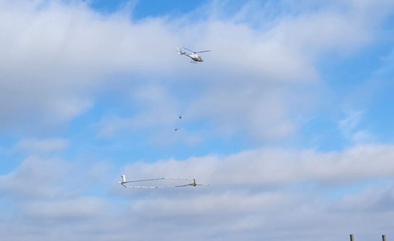
During several days last week, a helicopter hauling a huge antenna flew at low altitudes over rural Champaign County. The antenna sent electromagnetic waves into the ground about 100 feet below, where they bounced off of underground rock and sediment formations, and were picked up by sensors mounted on the antenna’s frame. In this way the antenna gathered data revealing the location of formations that indicate the presence of an aquifer. Researchers will use the data to make a precise map of the Mahomet Aquifer, east-central Illinois’ principal water supply.
The helicopter and antenna took off from the Frasca Field airport in Urbana on December 7, in a demonstration for reporters. The antenna, looking something like a tennis racquet frame and weighing more than a half-ton, dwarfed the helicopter above it.
HTEM Technology
The Danish company SkyTEM developed the technology, called helicopter-borne transient electromagnetic or HTEM technology. The Illinois State Geological Survey hired SkyTEM to scan the rural areas of Champaign County (HTEM won’t work in built-up urban areas) to produce a map of the Mahomet Aquifer within the county’s borders.
While researchers have a general idea of the aquifer’s location from water wells and geological borings, the HTEM mapping project will provide data that can help make a more detailed picture of the underground water supply.
Geologist Jason Thomason with the state Geological Survey says it’s important to have as much data as possible, both from HTEM technology, and by drilling for bore samples that show the actual composition of the ground below.
“From a geologist point of view, this level of certainty increases when we have those drill points and other data that can help check the electrical element (and provide) validation of this data,” said Thomason. “We have a good idea of what the data means, when they come back. But it’s always cross-checking with other data that we already have (that) helps us fill in all the gaps between.
Understanding an Aquifer’s Capacity
University of Illinois Professor Praveen Kumar directs the university’s Prairie Research Institute, which includes the state Geological Survey that is overseeing the mapping. He says getting a precise map of the aquifer will help them understand how much water it contains, and whether that water is being replenished as quickly as it’s used.
“For its sustainable use, whatever we’re pulling out has to be recharged somewhere,” said Kumar. “Otherwise, you are just sucking it all out and drying it up. And the whole idea of this mapping is so we can figure out what its capacity is, what its recharge capacity is, so we can figure out what is its sustainable use.”
The drying-up of an aquifer is a real problem for some communities. Chris Stohr is a geologist with the state Geological Survey, and also a member of the Champaign County Board. The county provided $500,000 in federal American Recovery Act funds to support the aquifer mapping project.
Stohr says the plight of communities in the Joliet area west of Chicago shows the importance of knowing as much about an aquifer’s capacity as one can. He says the communities (Joliet, Romeoville, Shorewood, Channahon, Lockport, Crest Hill, Oswego, Yorkville and Montgomery) are all dependent on the same aquifer for their water supply. But because water is coming out of the aquifer faster than it’s going in, Stohr says water levels have declined, creating the risk of total depletion for these communities.
“Several have seen 700 to 1000 feet of decline of their static water level,” said Stohr at the Dec. 7 news conference. “The pumps have been lowered in the wells as far as they can, and there’s only maybe 50 to 100 feet of water above them. They have a supply for maybe 10 to 20 years. In one instance, less than five years of supply in their aquifer. These were once communities that had so much they didn’t know what to do with. Now they’re in crisis.”
To get a better picture of the Mahomet Aquifer, geologists will have to map all of it, and the current mapping project only covers Champaign County.
Geologist Thomason says they hope to find funding to map the rest of the aquifer.
“We were lucky enough that Champaign County was willing to invest in this,” said Thomason. “And we want try to use that as a way of … showing people that it works, and try to leverage more money from other resources, sure.”
The Mahomet Aquifer lies underneath a total of 15 Illinois counties, from the Illinois River to the Indiana border.